TOWN & BUSINESS INDEX PAGE
HOME PAGE
OLD PLANK ROAD WAS HISTORY LINK
FOR FARMINGTON AREA COMMUNITIES |
|
It was
billed as the longest, most famous and best plank road ever built. It began in Ste. Genevieve, ran to Iron Mountain
and on to Pilot Knob. But Farmington took
advantage of its location and became a hub of development and shipping for the teamsters
moving along the road.
Built during the 1850s, the road had reached
from Ste. Genevieve to Farmington by 1853. It
continued to Iron Mountain and finished late in 1855.
At a cost of $200,000 the r42 miles of wood-surfaced highway served as a link
between area iron mines and the supply and shipping links needed by those mines.
There were five
too gates along the route, two of them between Farmington and Doe Run. A journey along the road would cost a man with a
wagon of supplies 25 cents for the round trip. His
counterpart on a horse would be charged only 10 cents at the gates.
Despite the state
officials’ warnings that gravel roads were better and smoother, use of the plank road
continued because people dreamed of traveling over mud-free roads.
Construction of
the road was simple, but top engineers of the time were employed to develop plans for the
road. The builder, a corporation formed in Jefferson
City on Feb. 7, 1851, wanted to make sure every thing was right because it saw the route
between the iron mines and the Mississippi River at Ste. Genevieve as a vital link for the
future.
The road was
built with planks 8 feet long and 2 inches thick.
The road was
constructed in a series of 8-foot sections with planks to tie them together. Local saw mills along the road cut the timber that
was hauled to the construction sites.
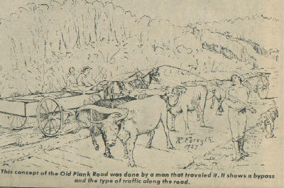
Being only 8
feet wide the road allowed only one-way traffic for the three-ox teams that carried
massive loads of iron ore. Westbound traffic
had the right-of-way. Teams going east had to
wait at one of the cutoffs to allow westbound traffic to pass. A round trip on the road took five days. Many of the teamsters made the round trip each
week. As one put it, “we didn’t get
rich but we did make a living.”
John Hunt, who
often used the road between Farmington and Doe Run, learned what he later described as a
most valuable lesson.
“I drove
the road a lot at night,” Hunt later told a historian.
“I got into the habit of passing the toll gate and just calling out my
name.”
The gatekeepers
would then charge the bill to Hunt. At the end
of the month he would settle with them, Hunt said.
Other
teamsters learned his trick and would pass through at night and call out, “The team
of John Hunt.” After Hunt got his bill,
at the end of the month he paid cash on each trip.
The use of toll gates along the road began declining as more roads opened. But the part of the toll road through St. Francois
County continued to operate under a firm called the St. Francois County Gravel Road Co.
In 1902 St. Francois County
purchased the road and made it a toll-free part of the county system.
Parts of the
old Road may still be seen. One marker is
along Route 32 between Farmington and Ste. Genevieve.
Part of Route 32 runs along the old plank road and there are other sections or
roads that use part of the old right of way.
While its history was
short and it was not what the builders had hoped, the plank road provided a vital link
between supplier and miner. It also provided
an important basis for growth in Farmington in the 1850s.
The Daily Journal, Flat River, Mo., Monday, March 19, 1979/Transcribed by Jeanne
Hunt Nassaney.
Note: For
further articles on the Old Plank Road, please see the Highways & By-Ways section of our web site.
TOWN &
BUSINESS INDEX PAGE
HOME PAGE
This page was updated: Friday, 23-Feb-2024 12:43:18 MST
This site may be freely linked, but not duplicated in any way without consent.
All rights reserved! Commercial use of material within this site is prohibited!
© 2000 - 2024 MOGenWeb
The information on this site is provided free for the purpose of researching your genealogy. This material may be freely used by non-commercial entities, for your own research. The information contained in this site may not be copied to any other site without written "snail-mail" permission. If you wish to have a copy of a donor's material, you must have their permission. All information found on these pages is under copyright of Oklahoma Cemeteries. This is to protect any and all information donated. The original submitter or source of the information will retain their copyright. Unless otherwise stated, any donated material is given to
MOGenWeb to make it available online.