 |
|
|
|
�����������
It once was a small but industrialized area east of
�����������
�����������
The smelter was on the east end of the community.�
The town, consisting of little more than two rows of workers� houses running
east and west, and, also had a school, store and flour mill.�
That mill was the Giessing & Sons firm, which in 1896 moved to
�����������
The town was inhabited by employees of the mill and smelter.
�����������
Railroads brought the end to the community.� Completion
of the
�����������
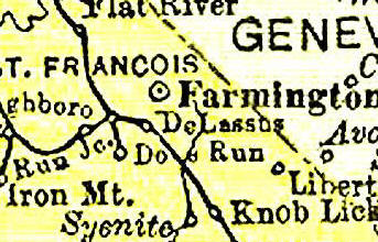
Delassus might have been the seat of
�����������
The community which borders
�����������
Delassus was laid out as a town in 1869 on property owned by Marie Jean B.
DeLassus, the last of the Spanish rulers of
�����������
It was originally 24 � blocks, with two set aside for public use. � Four and one-half blocks were situated west of the
�����������
The community appeared to have a bright future, strengthened by its location on the
Belmont and the
�����������
It was the
�����������
In the late 1870s, a toll gate on the
�����������
However, the toll gate question was solved, and Delassus� chance ended, by the
closing of the
�����������
�����������
Surveyed in 1870 by Zebulon Murphy, the town consisted of four irregular blocks.� The principal avenue was
�����������
Properties of Salt gave Knob Lick its name.
�����������
Located seven miles south of
�����������
The community was important because it served as a shipping point for the granite
quarries located in the southern portions of the county.�
Just west of Knob Lick is one of the granite peaks of the
�����������
The hills provided an industry for the community, with the Syenite granite works
providing much of the stone.� The quarry
produced quality stone for W.R. Allen and Co.� Granite
in the area was used for paving stones (cobblestones), buildings of various kinds (many
county residents have contended the present county courthouse should have been built with
native granite instead of limestone) and monumental blocks.
�����������
Electric Place was founded because of the county�s electrical railroad line.� It was also called Power House.
�����������
The electric railroad maintained a generating plant for direct current power to its
inter-urban streetcars and built homes for its employees.�
It was located on the southeast side of the present
����������� The community was originally surveyed in 1907, and consisted of 9.94 acres of ground, with 23 lots.� The tracts had been owned by Marvin A. Young, C.B. Denman and Anna Denman.
Thanks goes out to Jeanne "Hunt" Nassaney for typing above article for us.
The information on this site is provided free for the purpose of researching your genealogy. This material may be freely used by non-commercial entities, for your own research. The information contained in this site may not be copied to any other site without written "snail-mail" permission. If you wish to have a copy of a donor's material, you must have their permission. All information found on these pages is under copyright of Oklahoma Cemeteries. This is to protect any and all information donated. The original submitter or source of the information will retain their copyright. Unless otherwise stated, any donated material is given to MOGenWeb to make it available online.