HOME PAGE
MAPS OF ST. FRANCOIS COUNTY, MISSOURI AND SURROUNDING AREAS |
|
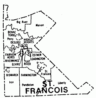
ST. FRANCOIS COUNTY TOWNSHIP MAP The county of St. Francois was developed from the counties of JEFFERSON, STE. GENEVIEVE and WASHINGTON Counties, on December 19, 1821. The counties were divided into four townships after February 1822, the townships were called St. Francois, Pendleton, Perry and Liberty. In August 1836, Marion township was formed from the northern part of Perry township. 1840 Black River township was formed then ten years later Iron township was formed from the area above Iron county. The last two townships were formed five years apart, Randolph in 1858 and Big River in 1863. |
OTHER MAPS OF INTEREST: |
|
Click HERE to view map of St. Francois County from 1895 Atlas. | |
Click HERE to view Civil War era map of Southeast Missouri. | |
Click HERE to view hand-drawn plat of [Old] East Bonne Terre, Missouri. | |
St. Francois Mountains Map (article) | Map - Counties of the Ozark Region |
Map - Sub-Regions of the Ozarks | |
1930
Plat Map of St. Francois County |
The information on this site is provided free for the purpose of researching your genealogy. This material may be freely used by non-commercial entities, for your own research. The information contained in this site may not be copied to any other site without written "snail-mail" permission. If you wish to have a copy of a donor's material, you must have their permission. All information found on these pages is under copyright of Oklahoma Cemeteries. This is to protect any and all information donated. The original submitter or source of the information will retain their copyright. Unless otherwise stated, any donated material is given to MOGenWeb to make it available online.